Datoteka:Transasia trade routes 1stC CE gr2.png

Transasia_trade_routes_1stC_CE_gr2.png(800 × 480 piksela, veličina datoteke/fajla: 218 kB, MIME tip: image/png)

Ova datoteka je s projekta Vikimedijina ostava i može se upotrebljavati i na drugim projektima. Ispod su prikazane informacije s njene opisne stranice.

This map image could be re-created using vector graphics as an SVG file. This has several advantages; see Commons:Media for cleanup for more information. If an SVG form of this image is available, please upload it and afterwards replace this template with {{vector version available|new image name}}.


It is recommended to name the SVG file “Transasia trade routes 1stC CE gr2.svg”—then the template Vector version available (or Vva) does not need the new image name parameter.

Opis izmjene

Dostupna je vektorska inačica (SVG) ove slike. Trebala bi se koristiti umjesto ove rasterske slike ako je kvalitetnija. (razlog: coloured version, white version still needs to be created)

File:Transasia trade routes 1stC CE gr2.png → File:Silk Road in the I century AD - ru.svg

Za više informacija o vektorskoj grafici, pročitajte o prelasku Zajedničkog poslužitelja na SVG.
Također pročitajte informacije o podršci MediaWiki softvera slikama u SVG formatu.

Na drugim jezicima
Alemannisch  Bahasa Indonesia  Bahasa Melayu  British English  català  čeština  dansk  Deutsch  eesti  English  español  Esperanto  euskara  français  Frysk  galego  hrvatski  Ido  italiano  lietuvių  magyar  Nederlands  norsk bokmål  norsk nynorsk  occitan  Plattdüütsch  polski  português  português do Brasil  română  Scots  sicilianu  slovenčina  slovenščina  suomi  svenska  Tiếng Việt  Türkçe  vèneto  Ελληνικά  беларуская (тарашкевіца)  български  македонски  нохчийн  русский  српски / srpski  татарча/tatarça  українська  ქართული  հայերեն  বাংলা  தமிழ்  മലയാളം  ไทย  한국어  日本語  简体中文  繁體中文  עברית  العربية  فارسی  +/−
Nova SVG slika

Licenciranje

Ja, vlasnik autorskog prava ovog djela, ovdje ga objavljujem pod sljedećim licencama:
GNU head Dopušteno je umnožavanje, dijeljenje i mijenjanje ovog dokumenta pod uslovima GNU-ove licence za slobodnu dokumentaciju, verzije 1.2 ili bilo koje novije koju objavi Fondacija za slobodni softver; bez nepromjenljivih odjeljaka i bez tekstova na naslovnoj i zadnjoj strani. Tekst licence možete pročitati ovdje.
w:bs:Creative Commons
pripisivanje dijeljenje pod istim uslovima
Ova datoteka dostupna je pod licencom Creative Commons Attribution-Share Alike 3.0 Unported licencom.
Slobodno smijete:
  • dijeliti – umnožavati, raspodjeljivati i prenositi djelo
  • prerađivati – prilagođavati djelo
Pod sljedećim uslovima:
  • pripisivanje – Morate pripisati odgovarajuće autorske zasluge, osigurati link ka licenci i naznačiti jesu li napravljene izmjene. To možete uraditi na bilo koji razumni način, ali ne tako da se sugerira da davalac licence odobrava Vas ili Vašu upotrebu njegovog djela.
  • dijeljenje pod istim uslovima – Ako mijenjate, transformišete ili nadograđujete ovaj materijal, morate ga objaviti i distribuirati samo pod istom ili sličnom licencom poput ove.
Ova oznaka licence je dodana na ovu datoteku kao dio GFDL ažuriranja licence.
Možete odabrati licencu po vašem izboru.

Map information

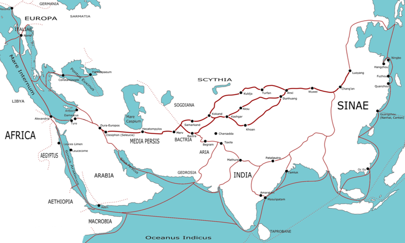
This map indicates trading routes used around the 1st century CE centred on the Silk Road. The routes remain largely valid for the period 520 BCE to 500 CE.

Geographical labels for regions are adapted from the Geography of Ptolemy (c. 150 CE), some trading centre names date from later (c. 400 CE). Relying on Ptolemy's names is wrong but neutral.

The following contemporary trading centres (or possible trading centres) are not marked:

Red Sea - Myos Hormos, Berenica, Ptolemais Theron, Adulis, Muza, Ocalis, Aualites, Malao.

Arabia - [South] Saue, Sana, Saphar, Eudaemon Arabia, Cane, Mosyllon, Moscha

Persian Gulf - Asabon, Charax, Gerra, Ommana, Apologos

Persia - Persepolis, Alexandria Areion, Kandahar

Africa - [East Africa/Kush/Axum] Coloe, Axum, Akhmim, Panopolis, Aromaton Emporion, Opone, Sarapion, Dongola. [Mediterranean] Cyrene, Leptis Magna, Carthage, Caesarea, [Beyond map] [East Africa] Juba, Maji, Sennar, [Trans-Saharan] Sijilmassa, Tamanrasset, Murzuk, Tingis.

Europe - Gades (Cadiz), Augusta Treverorum (Trier), Aquileia, Ostia, Athens

India - [Arabian Sea] Horaia, Barbaricum, Barake, Astakapra, Suppara, Kalliena, Semylla, Mandagora, Palaepatmae, Melizeigara, Erannoboas, Byzantion, Naura, Tymdis, [Central] Paethana, Tagara, [South] Muziris, Nelcynda, Bacare, Balita, Colchi, Palaesimundu, [East] Argaru, Poduca, Sopatma.

Silk Road - Ecbatana, Yarkand, Jiaohei, Kitai, Kaifeng. (Note - both summer and winter routes around the Takla Makan are shown)

China - Chengdu, Kunming, Cattgara

South East Asia - Trang, Thaton

The routes between most of these unindicated sites are not marked, notably the extensive European/Roman routes and the other routes in Persia beyond the Silk Road. Another route not indicated is the Scythian route running from China to the Black Sea. The large number not marked on India are the minor sites listed in the Periplus of the Erythraean Sea.

Origins of trade goods

China - silk, clothing, lacquerware, spices

Indo-China - spices, ivory, timber, pearls

Northern India - precious stones, ivory, tortoiseshell, incense, spices, cloth, timber

Southern India - ivory, tortoiseshell, spices, precious stones, cloth, timber

Arabia - spices, slaves, precious stones

East Africa - gold, ivory, exotic animals, slaves, incense

Trans-Sahara - ivory, gold, slaves

North Africa - grain,

Southern Europe - olive oil, wine, glassware, coinage

Western Europe - silver, tin

Northern Europe - slaves, amber,

Asia Minor - silver, precious stones, timber, wine

Image editing

The source for this PNG was an SVG. This file is available.


from en wp

(del) (cur) 23:55, 30 March 2006 . . TwoOneTwo (Talk) . . 1223x794 (374899 bytes)


  • (cur) (last) 00:12, 31 March 2006 82.24.208.109 (→Map information)
  • (cur) (last) 00:00, 31 March 2006 TwoOneTwo m
  • (cur) (last) 23:55, 30 March 2006 TwoOneTwo
Annotations
InfoField
This image is annotated: View the annotations at Commons

Opisi

Dodajte objašnjenje u jednom redu što predstavlja ova datoteka

Predmeti pokazani na ovoj datoteci

prikazuje

vrsta medija na Internetu Serbian (Latin script)

image/png

kontrolna suma Srpski (transliteracija)

9c242d0941efe86f2a49bc8d9bcd58e068032287

veličina podatka Srpski (transliteracija)

223.663 Bajt

480 piksel

800 piksel

Historija datoteke

Kliknite na datum/vrijeme da biste vidjeli tadašnju verziju datoteke.

Datum/vrijemeMinijaturaDimenzijeKorisnikKomentar
aktualna03:43, 18 februar 2021Minijatura verzije (03:43, 18 februar 2021)800 × 480 (218 kB)MrPersonHumanGuyPurging the page didn't work, so I'm trying this again a third time
02:52, 18 februar 2021Minijatura verzije (02:52, 18 februar 2021)800 × 480 (202 kB)MrPersonHumanGuyWell that didn't work, trying again (I'm wondering why it's only showing the previous version)
02:45, 18 februar 2021Minijatura verzije (02:45, 18 februar 2021)800 × 480 (182 kB)MrPersonHumanGuyfixed Macrobia
01:03, 9 januar 2013Minijatura verzije (01:03, 9 januar 2013)800 × 480 (182 kB)RunehelmetRegion added
12:32, 4 juni 2012Minijatura verzije (12:32, 4 juni 2012)1.194 × 716 (264 kB)Mayhaymateoptimized
05:21, 3 juni 2006Minijatura verzije (05:21, 3 juni 2006)1.194 × 716 (308 kB)Stevertigo (usurped)cropped version - needs more work - requested the SVG from original creator.
16:56, 20 april 2006Minijatura verzije (16:56, 20 april 2006)1.223 × 794 (366 kB)Shizhao== Licensing == {{GFDL-self}} == Map information == This map indicates trading routes used around the 1st century CE centred on the Silk Road. The routes remain largely valid for the period 500 BCE to 500 CE. Geographical labels for regions are adap

Sljedeća stranica koristi ovu datoteku:

Globalna upotreba datoteke

Ovu datoteku upotrebljavaju i sljedeći projekti:

Potpunija globalna upotreba datoteke

Metapodaci