Datoteka:North West England counties 2009 map.svg

Veličina ovog PNG-pregleda ove SVG-datoteke: 300 × 599 piksela. Druge rezolucije: 120 × 240 piksela | 240 × 480 piksela | 385 × 768 piksela | 513 × 1.024 piksela | 1.026 × 2.048 piksela | 674 × 1.345 piksela.
Izvorna datoteka (SVG fajl, nominalno 674 × 1.345 piksela, veličina fajla: 1,39 MB)
Opis izmjene
| Opis |
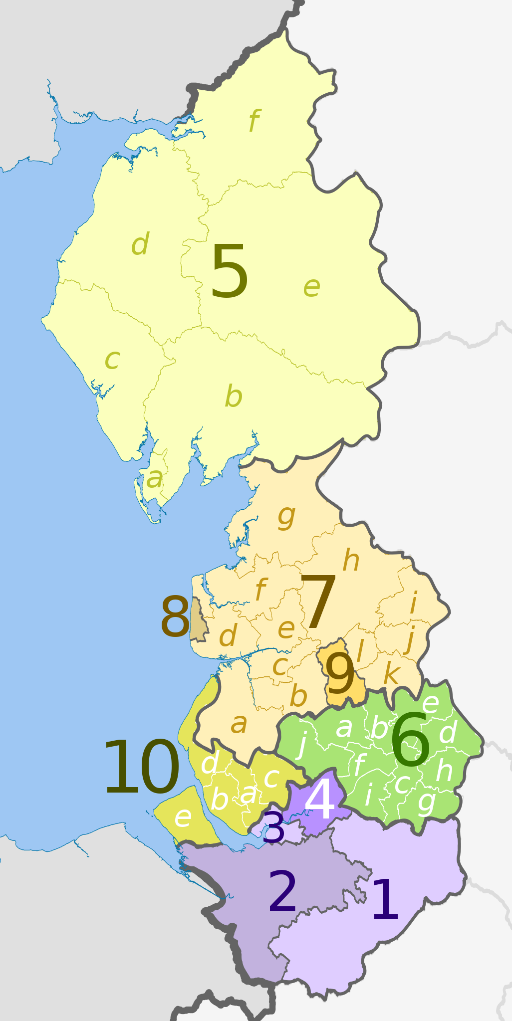
English: Map of the North West England region, showing its counties and administrative districts until 31 March 2023. The county colours are the same as those in File:English metropolitan and non-metropolitan counties 2009.svg.
For counties since 1 April 2023, see File:North West England counties 2023 map.svg. Equirectangular map projection on WGS 84 datum, with N/S stretched 170% Geographic limits:
|
| Datum | (UTC) |
| Izvor |
Ova je datoteka izvedena iz: |
| Autor |
|
| Ostale verzije | File:North West England counties 2023 map.svg – version since 1 April 2023 |


| Map | Ceremonial county | County/Unitary | Metropolitan/non-metropolitan districts |
|---|---|---|---|
 |
Cheshire | 1. Cheshire East U.A. | |
| 2. Cheshire West and Chester U.A. | |||
| 3. Halton U.A. | |||
| 4. Warrington U.A. | |||
| 5. Cumbria † | a) Barrow-in-Furness, b) South Lakeland, c) Copeland, d) Allerdale, e) Eden, f) Carlisle | ||
| 6. Greater Manchester * | a) Bolton, b) Bury, c) Manchester, d) Oldham, e) Rochdale, f) Salford, g) Stockport, h) Tameside, i) Trafford, j) Wigan | ||
| Lancashire | 7. Lancashire † | a) West Lancashire, b) Chorley, c) South Ribble, d) Fylde, e) Preston, f) Wyre, g) Lancaster, h) Ribble Valley, i) Pendle, j) Burnley, k) Rossendale, l) Hyndburn | |
| 8. Blackpool U.A. | |||
| 9. Blackburn with Darwen U.A. | |||
| 10. Merseyside * | a) Knowsley, b) Liverpool, c) St. Helens, d) Sefton, e) Wirral | ||
Key: †shire county | *metropolitan county
Licenciranje
Ova datoteka dostupna je pod licencom Creative Commons Attribution-Share Alike 3.0 Unported licencom.
Pripisivanje: Dr Greg and Nilfanion. Contains Ordnance Survey data © Crown copyright and database right 2011
- Slobodno smijete:
- dijeliti – umnožavati, raspodjeljivati i prenositi djelo
- prerađivati – prilagođavati djelo
- Pod sljedećim uslovima:
- pripisivanje – Morate pripisati odgovarajuće autorske zasluge, osigurati link ka licenci i naznačiti jesu li napravljene izmjene. To možete uraditi na bilo koji razumni način, ali ne tako da se sugerira da davalac licence odobrava Vas ili Vašu upotrebu njegovog djela.
- dijeljenje pod istim uslovima – Ako mijenjate, transformišete ili nadograđujete ovaj materijal, morate ga objaviti i distribuirati samo pod istom ili sličnom licencom poput ove.
Izvorna evidencija postavljanja
This image is a derivative work of the following images:
- File:North_West_England_districts_2011_map.svg licensed with Cc-by-sa-3.0, GFDL
- 2011-05-01T19:03:10Z Nilfanion 674x1345 (1403071 Bytes) == Summary == {{Information |Description=Map of the [[w:North West England|North West England]] region showing the administrative districts. Equirectangular map projection on WGS 84 datum, with N/S stretched 170% Geographic
- File:English_ceremonial_counties_2010.svg licensed with Cc-by-sa-3.0, GFDL
- 2010-11-23T16:39:55Z Nilfanion 1108x1345 (308868 Bytes) thicker lines
- 2010-11-23T16:20:19Z Nilfanion 1108x1345 (301520 Bytes) tweaks
- 2010-10-26T20:34:20Z Nilfanion 817x990 (1391832 Bytes) {{Information |Description=Map showing the [[w:ceremonial counties of England]] including the City of London, in 2010. Equirectangular map projection on WGS 84 datum, with N/S stretched 170% Geographic limits: *West: 6.75W
Uploaded with derivativeFX
Historija datoteke
Kliknite na datum/vrijeme da biste vidjeli tadašnju verziju datoteke.
| Datum/vrijeme | Minijatura | Dimenzije | Korisnik | Komentar | |
|---|---|---|---|---|---|
| aktualna | 22:08, 5 maj 2012 | | 674 × 1.345 (1,39 MB) | Dr Greg | lighten black boundary line |
| 01:16, 2 maj 2012 |  | 674 × 1.345 (1,39 MB) | Dr Greg | == {{int:filedesc}} == {{Information |Description={{en|Map of the North West England region, showing its counties and administrative districts. The county colours are the same as those in [[:File:English metropolitan and non-me... |
Upotreba datoteke
Sljedeća stranica koristi ovu datoteku:
Globalna upotreba datoteke
Ovu datoteku upotrebljavaju i sljedeći projekti:
- Upotreba na projektu ar.wikipedia.org
- Upotreba na projektu fa.wikipedia.org
- Upotreba na projektu frr.wikipedia.org
- Upotreba na projektu hr.wikipedia.org
- Upotreba na projektu hu.wikipedia.org
- Upotreba na projektu mr.wikipedia.org
- Upotreba na projektu no.wikipedia.org
- Upotreba na projektu pl.wikipedia.org
- Upotreba na projektu pnb.wikipedia.org
- Upotreba na projektu pt.wikipedia.org
- Upotreba na projektu ru.wikipedia.org
- Upotreba na projektu th.wikipedia.org
- Upotreba na projektu ur.wikipedia.org
- Upotreba na projektu vi.wikipedia.org
- Upotreba na projektu vls.wikipedia.org
- Upotreba na projektu zh-yue.wikipedia.org