Datoteka:Militargrenze, Wojwodowena und Banat.jpg
Izvorna datoteka (900 × 312 piksela, veličina datoteke/fajla: 115 kB, MIME tip: image/jpeg)
| Opis |
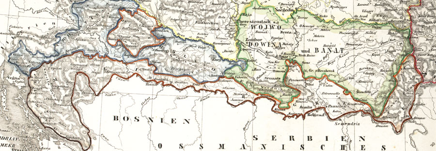
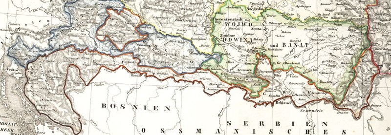
Deutsch: Karte der österreichischen Militärgrenze aus dem 19. Jahrhundert.
English: Historic map of the military frontier of Austria-Hungary, also named Krajina, and of Vojvodina
Français : Carte historique des confins militaires en Autriche-Hongrie aussi appelé Krajina |
||||
| Datum | 2004 | ||||
| Izvor | de:Bild:Militärgrenze.jpg | ||||
| Autor | Scan plp | ||||
| Dopuštenje (Ponovna upotreba ove datoteke) |
|
||||
| Ostale verzije |
 |
||||
| Annotations | This image is annotated: View the annotations at Commons |
Historija datoteke
Kliknite na datum/vrijeme da biste vidjeli tadašnju verziju datoteke.
| Datum/vrijeme | Minijatura | Dimenzije | Korisnik | Komentar | |
|---|---|---|---|---|---|
| aktualna | 06:57, 26 septembar 2008 | 900 × 312 (115 kB) | Nikola Smolenski | {{Information |Description={{de|Karte der österreichischen de:Militärgrenze aus dem 19. Jahrhundert.}} {{en|Historic map of the military frontier of Austria-Hungary, also named w:Krajina, and of w:Vojvodina}} {{fr|Carte historique des con |
Upotreba datoteke
Sljedećih 3 stranica koriste ovu datoteku:
Globalna upotreba datoteke
Ovu datoteku upotrebljavaju i sljedeći projekti:
- Upotreba na projektu azb.wikipedia.org
- Upotreba na projektu be-tarask.wikipedia.org
- Upotreba na projektu bg.wikipedia.org
- Upotreba na projektu bs.wikipedia.org
- Upotreba na projektu cs.wikipedia.org
- Upotreba na projektu da.wikipedia.org
- Upotreba na projektu de.wikipedia.org
- Upotreba na projektu en.wikipedia.org
- Upotreba na projektu eo.wikipedia.org
- Upotreba na projektu es.wikipedia.org
- Upotreba na projektu et.wikipedia.org
- Upotreba na projektu fa.wikipedia.org
- Upotreba na projektu fr.wikipedia.org
- Upotreba na projektu gl.wikipedia.org
- Upotreba na projektu hr.wikipedia.org
- Upotreba na projektu hu.wikipedia.org
- Upotreba na projektu id.wikipedia.org
- Upotreba na projektu it.wikipedia.org
- Upotreba na projektu ja.wikipedia.org