Datoteka:Kuunga2.png

Veličina ovog prikaza: 750 × 600 piksela. Druge rezolucije: 300 × 240 piksela | 600 × 480 piksela | 960 × 768 piksela | 1.150 × 920 piksela.
Izvorna datoteka (1.150 × 920 piksela, veličina datoteke/fajla: 153 kB, MIME tip: image/png)

|
This geology image could be re-created using vector graphics as an SVG file. This has several advantages; see Commons:Media for cleanup for more information. If an SVG form of this image is available, please upload it and afterwards replace this template with
{{vector version available|new image name}}.
It is recommended to name the SVG file “Kuunga2.svg”—then the template Vector version available (or Vva) does not need the new image name parameter. |
Opis izmjene
| Opis |
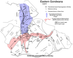
English: Paleotectonic map of eastern Gondwana with the Pan-African and/or circum-Antarctic orogenic (“mobile”) belts highlighted by age differences (See Fitzsimons, 2000a, cited in Meert, 2003, follow source link below). Meaning of abbreviations: Af = Afif terrane (Saudi Arabia); AFB = Albany-Fraser Belt (Australia); AS = Angavo shear zone (Madagascar); BH = Bunger Hills (Antarctica); BR = Bongolava-Ranotsara shear zone (Madagascar); BS = Betsimisaraka suture zone (Madagascar); DB = Damara Belt (Africa); DDS = Darling-Denman suture (Antarctica - Australia); DG = Denman Glacier (Antarctica); DMS = Dronning Maud suture (Antarctica); EG = Eastern Ghats (India); GB = Gariep Belt (Africa); HC = Highland Complex (Sri Lanka); LA = Lufilian Arc (Africa); LG = Lambert Graben (Antarctica); LHB = Lützow-Holm Belt (Antarctica); MD = Mwembeshi Dislocation (Africa); MP = Maud Province (Antarctica); NBS = Nabitah Suture (Arabia); nPCSM = Northern Prince Charles Mountains (Antarctica); NQ = Namaqua Belt (Africa); OSH = Onib-Sol Hamed suture (Arabia); PBB = Prydz Bay Belt (Antarctica); PC = Paughat-Cauvery (India); SB = Saldania Belt (Africa); SR = Shackelton Range (Antarctica) ; UAA = Urd Al Amar suture (Arabia); VC = Vijayan Complex (Sri Lanka); WC = Wanni Complex (Sri Lanka); WI = Windmill Islands (Antarctica); ZB = Zambezi Belt (Africa). |
| Datum | (UTC) |
| Izvor | Kuunga2.jpg |
| Autor |
|
Licenciranje
Ja, vlasnik autorskog prava ovog djela, ovdje ga objavljujem pod sljedećom licencom:
| |
Ovaj rad je objavljen u javno vlasništvo od strane autora Example, at the [[::|Engleski Wikipedia]] project. Ovo se primjenjuje širom svijeta. In case this is not legally possible: |
Izvorna evidencija postavljanja
This image is a derivative work of the following images:
- File:Kuunga2.jpg licensed with PD-user-w
- 2008-02-29T10:16:24Z File Upload Bot (Magnus Manske) 1000x785 (220296 Bytes) {{BotMoveToCommons|en.wikipedia}} {{Information |Description={{en|http://www.clas.ufl.edu/users/jmeert/kuunga.jpg adapted from: Meert, J.G., A synopsis of events related to the assembly of eastern Gondwana, Tectonophysics,
Uploaded with derivativeFX
Historija datoteke
Kliknite na datum/vrijeme da biste vidjeli tadašnju verziju datoteke.
| Datum/vrijeme | Minijatura | Dimenzije | Korisnik | Komentar | |
|---|---|---|---|---|---|
| aktualna | 02:08, 8 novembar 2010 | | 1.150 × 920 (153 kB) | Mikhail Ryazanov | {{Information |Description={{en|Orogens and Kuungan Orogens.}} |Source=*File:Kuunga2.jpg |Date=2010-11-08 00:06 (UTC) |Author=*File:Kuunga2.jpg: Jmeert *derivative work: ~~~ |Permission= |other_versions= }} {{self|PD-user- |
Upotreba datoteke
Sljedeća stranica koristi ovu datoteku:
Globalna upotreba datoteke
Ovu datoteku upotrebljavaju i sljedeći projekti:
- Upotreba na projektu af.wikipedia.org
- Upotreba na projektu de.wikipedia.org
- Upotreba na projektu el.wikipedia.org
- Upotreba na projektu en.wikipedia.org
- Upotreba na projektu fr.wikipedia.org
- Upotreba na projektu it.wikipedia.org
- Upotreba na projektu it.wikibooks.org
- Upotreba na projektu it.wikiversity.org
- Upotreba na projektu mk.wikipedia.org
- Upotreba na projektu nds.wikipedia.org
- Upotreba na projektu nl.wikipedia.org
- Upotreba na projektu no.wikipedia.org
- Upotreba na projektu sr.wikipedia.org
- Upotreba na projektu uk.wikipedia.org
- Upotreba na projektu zh.wikipedia.org