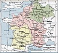
Datoteka:Francia at the death of Pepin of Heristal, 714.jpg

Izvorna datoteka(1.254 × 1.149 piksela, veličina datoteke/fajla: 1 MB, MIME tip: image/jpeg)

Ova datoteka je s projekta Vikimedijina ostava i može se upotrebljavati i na drugim projektima. Ispod su prikazane informacije s njene opisne stranice.

Opis izmjene

Opis
English: Francia at the death of Pepin of Heristal, 714
Français : Gaule à l'avènement de Charles Martel (714).
Datum
Izvor Paul Vidal de la Blache's Atlas général d'histoire et de géographie (1912). The original scanned image can be found at http://www.hipkiss.org/data/maps/vidal-lablache_atlas-general-histoire-et-geographie_1912_ancient-gaul-merovian-merovingienne_2953_4252_600.jpg. Information on the original scan can be found at http://www.hipkiss.org/cgi-bin/maps.pl?book=Vidal%20Lablache%20-%20Atlas%20General%20Histoire%20Et%20Geographie.
Autor
Paul Vidal de La Blache  (1845–1918)  wikidata:Q311865 s:fr:Auteur:Paul Vidal de La Blache q:fr:Paul Vidal de La Blache
 
Paul Vidal de La Blache
Alternativna imena
Paul Vidal de la Blanche
Opis francuski geograf i kartograf
Datum rođenja/smrti 22. januar 1845. Uredi na Wikidati 5. april 1918. Uredi na Wikidati
Mjesto rođenja/smrti Pézenas La Seyne-sur-Mer
Normativna kontrola
creator QS:P170,Q311865
Ostale verzije
Dostupna je vektorska inačica (SVG) ove slike. Trebala bi se koristiti umjesto ove rasterske slike ako je kvalitetnija.

File:Francia at the death of Pepin of Heristal, 714.jpg → File:Francia at the death of Pepin of Heristal 714-es.svg

Za više informacija o vektorskoj grafici, pročitajte o prelasku Zajedničkog poslužitelja na SVG.
Također pročitajte informacije o podršci MediaWiki softvera slikama u SVG formatu.

Na drugim jezicima
Alemannisch  Bahasa Indonesia  Bahasa Melayu  British English  català  čeština  dansk  Deutsch  eesti  English  español  Esperanto  euskara  français  Frysk  galego  hrvatski  Ido  italiano  lietuvių  magyar  Nederlands  norsk bokmål  norsk nynorsk  occitan  Plattdüütsch  polski  português  português do Brasil  română  Scots  sicilianu  slovenčina  slovenščina  suomi  svenska  Tiếng Việt  Türkçe  vèneto  Ελληνικά  беларуская (тарашкевіца)  български  македонски  нохчийн  русский  српски / srpski  татарча/tatarça  українська  ქართული  հայերեն  বাংলা  தமிழ்  മലയാളം  ไทย  한국어  日本語  简体中文  繁體中文  עברית  العربية  فارسی  +/−
Nova SVG slika

Licenciranje

This image is in the public domain because it is a mere mechanical scan or photocopy of a public domain original, or – from the available evidence – is so similar to such a scan or photocopy that no copyright protection can be expected to arise. The original itself is in the public domain for the following reason:
Public domain

Autor je umro 1918., tako da je ovo djelo u javnom vlasništvu u zemlji podrijetla i u drugim zemljama s rokom trajanja autorskih prava za života autora plus 100 godina ili manje.


Ovo je djelo u javnom vlasništvu u SAD-u zato jer je objavljeno (ili registrirano pri Uredu za autorska prava Sjedinjenih Američkih Država) prije 1. siječnja 1929.


This tag is designed for use where there may be a need to assert that any enhancements (eg brightness, contrast, colour-matching, sharpening) are in themselves insufficiently creative to generate a new copyright. It can be used where it is unknown whether any enhancements have been made, as well as when the enhancements are clear but insufficient. For known raw unenhanced scans you can use an appropriate {{PD-old}} tag instead. For usage, see Commons:When to use the PD-scan tag.


Note: This tag applies to scans and photocopies only. For photographs of public domain originals taken from afar, {{PD-Art}} may be applicable. See Commons:When to use the PD-Art tag.

Izvorna evidencija postavljanja

The original description page is/was here. All following user names refer to en.wikipedia.

  • 2007-08-19 21:33 Srnec 1241×1136×8 (353954 bytes) The map comes from Vidal-Lablache, ''Atlas général d'histoire et de géographie'' (1894). {{PD-art-life-70}}
  • 2007-09-10 16:34 Earthsound 1254 × 1149×8 (1 MB) Gaule at the time of Charles Martel (714). The scale is 1:12,000,000 This is a straightened and color balanced crop of a scan of a map from Paul Vidal de la Blache's 'Atlas général d'histoire et de géograp. {{PD-art-life-70}}

Opisi

Dodajte objašnjenje u jednom redu što predstavlja ova datoteka

Predmeti pokazani na ovoj datoteci

prikazuje

Historija datoteke

Kliknite na datum/vrijeme da biste vidjeli tadašnju verziju datoteke.

Datum/vrijemeMinijaturaDimenzijeKorisnikKomentar
aktualna16:26, 21 septembar 2019Minijatura verzije (16:26, 21 septembar 2019)1.254 × 1.149 (1 MB)OgreBot(BOT): Reverting to most recent version before archival
16:26, 21 septembar 2019Minijatura verzije (16:26, 21 septembar 2019)1.241 × 1.148 (349 kB)OgreBot(BOT): Uploading old version of file from en.wikipedia; originally uploaded on 2007-08-19 21:41:17 by Srnec
21:23, 22 januar 2008Minijatura verzije (21:23, 22 januar 2008)1.254 × 1.149 (1 MB)Vladimir Solovjev{{Information |Description={{en|This is a straightened and color balanced crop of a scan of a map from Paul Vidal de la Blache's ''Atlas général d'histoire et de géographie'' (1912).}} |Source=Transfered from [http://en.wikipedia.org

Sljedeća stranica koristi ovu datoteku:

Globalna upotreba datoteke

Ovu datoteku upotrebljavaju i sljedeći projekti:

Potpunija globalna upotreba datoteke