Datoteka:WW2 Holocaust Europe map-fr.svg

Veličina ovog PNG-pregleda ove SVG-datoteke: 721 × 600 piksela. Druge rezolucije: 289 × 240 piksela | 577 × 480 piksela | 923 × 768 piksela | 1.231 × 1.024 piksela | 2.461 × 2.048 piksela | 1.310 × 1.090 piksela.
Izvorna datoteka (SVG fajl, nominalno 1.310 × 1.090 piksela, veličina fajla: 841 kB)
Opis izmjene
| Opis |
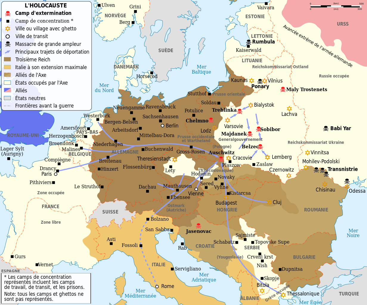
English: Map of the Holocaust in Europe during World War II, 1939-1945. This map shows all extermination camps (or death camps), most major concentration camps, labor camps, prison camps, ghettos, major deportation routes and major massacre sites.
Français : Carte de la Shoah en Europe lors de la Seconde Guerre mondiale (1939-1945). Cette carte montre tous les camps d'extermination (ou « camps de la mort ») et la plupart des principaux camps de concentration, de travail forcé, prisons, itinéraires de déportation et lieux de massacres.
Català: Mapa de L'Holocaust a Europa durant la Segona Guerra Mundial, 1939-1945.
|
||||
| Datum | (UTC) | ||||
| Izvor | |||||
| Autor |
|
||||
| Ostale verzije |
[]
Derivative works of this file:
| ||||
| Pripisivanje (required by the license) | © Sémhur / Wikimedia Commons / | ||||
| SVG |
Ova je vektorska slika napravljena programom Inkscape .
|
||||
| Graphic Lab |


.png)


.png)


| Lokacija kamere | | Ova i druge slike na njihovim lokacijama na: OpenStreetMap |
|---|
Licenciranje
Ja, vlasnik autorskog prava ovog djela, ovdje ga objavljujem pod sljedećim licencama:
| Copyleft: Ovaj umjetnički rad je slobodan, možete ga redistribuirati i/ili izmijeniti u skladu sa uslovima Free Art License. Primjerak ove licence možete naći na Copyleft Attitude stranici kao i na drugim stranicama. |
This file is licensed under the Creative Commons Attribution-Share Alike 4.0 International, 3.0 Unported, 2.5 Generic, 2.0 Generic and 1.0 Generic license.
- Slobodno smijete:
- dijeliti – umnožavati, raspodjeljivati i prenositi djelo
- prerađivati – prilagođavati djelo
- Pod sljedećim uslovima:
- pripisivanje – Morate pripisati odgovarajuće autorske zasluge, osigurati link ka licenci i naznačiti jesu li napravljene izmjene. To možete uraditi na bilo koji razumni način, ali ne tako da se sugerira da davalac licence odobrava Vas ili Vašu upotrebu njegovog djela.
- dijeljenje pod istim uslovima – Ako mijenjate, transformišete ili nadograđujete ovaj materijal, morate ga objaviti i distribuirati samo pod istom ili sličnom licencom poput ove.
Možete odabrati licencu po vašem izboru.
Izvorna evidencija postavljanja
This image is a derivative work of the following images:
- File:WW2-Holocaust-Europe.png licensed with Cc-by-3.0
- 2007-12-20T03:41:38Z Dna-webmaster 1310x1090 (845818 Bytes) new version without "Axis cooperating" in legend
- 2007-12-20T02:00:30Z Dna-webmaster 1310x1090 (844034 Bytes) Now entire West Prussia and Wartheland is included in the Third Reich
- 2007-12-19T16:42:15Z Dna-webmaster 1310x1090 (847461 Bytes) still not Da Vinci, but errors have been corrected (Germany borders West/East), West & East Prussia borders/coloring and Poland General Government corrected borders.
- 2007-12-17T10:46:28Z Dna-webmaster 1310x1090 (844633 Bytes) new map with 1942 borders, not Da Vinci, but here it goes...
- 2007-10-19T13:32:25Z Dna-webmaster 1310x1090 (784727 Bytes) and another update
- 2007-10-19T12:21:52Z Dna-webmaster 1310x1090 (789383 Bytes) quick fix
- 2007-10-19T12:11:07Z Dna-webmaster 1310x1090 (789413 Bytes) {{Information |Description=Map of the Holocaust in Europe during World War II, 1939-1945. This map shows all extermination camps (or ''death camps''), most major concentration camps, work camps, prison camps, ghettos, major
Uploaded with derivativeFX
Historija datoteke
Kliknite na datum/vrijeme da biste vidjeli tadašnju verziju datoteke.
| Datum/vrijeme | Minijatura | Dimenzije | Korisnik | Komentar | |
|---|---|---|---|---|---|
| aktualna | 17:24, 18 februar 2024 | | 1.310 × 1.090 (841 kB) | Ispanas | File uploaded using svgtranslate tool (https://svgtranslate.toolforge.org/). Added translation for lt. |
| 15:30, 18 februar 2024 |  | 1.310 × 1.090 (841 kB) | Ispanas | File uploaded using svgtranslate tool (https://svgtranslate.toolforge.org/). Added translation for lt. | |
| 09:20, 22 septembar 2023 |  | 1.310 × 1.090 (841 kB) | EnjolrasXXI | File uploaded using svgtranslate tool (https://svgtranslate.toolforge.org/). Added translation for ca. | |
| 23:25, 27 august 2023 |  | 1.310 × 1.090 (733 kB) | Tholme | Reverted to version as of 14:45, 28 February 2023 (UTC) | |
| 23:24, 27 august 2023 |  | 1.310 × 1.090 (490 kB) | Tholme | Reverted to version as of 14:47, 3 June 2021 (UTC) | |
| 16:45, 28 februar 2023 |  | 1.310 × 1.090 (733 kB) | Andrei Stroe | File uploaded using svgtranslate tool (https://svgtranslate.toolforge.org/). Added translation for ro. | |
| 21:26, 29 oktobar 2022 |  | 1.310 × 1.090 (625 kB) | Ispanas | File uploaded using svgtranslate tool (https://svgtranslate.toolforge.org/). Added translation for lt. | |
| 09:32, 13 septembar 2021 |  | 1.310 × 1.090 (490 kB) | BIG DADDY Dunkleosteus | Reverted to version as of 14:47, 3 June 2021 (UTC) | |
| 09:31, 13 septembar 2021 |  | 1.310 × 1.090 (555 kB) | BIG DADDY Dunkleosteus | File uploaded using svgtranslate tool (https://svgtranslate.toolforge.org/). Added translation for en. | |
| 16:47, 3 juni 2021 |  | 1.310 × 1.090 (490 kB) | Tholme | remove another nested tspan |
Upotreba datoteke
Sljedeća stranica koristi ovu datoteku:
Globalna upotreba datoteke
Ovu datoteku upotrebljavaju i sljedeći projekti:
- Upotreba na projektu ca.wikipedia.org
- Upotreba na projektu de.wikipedia.org
- Upotreba na projektu en.wikipedia.org
- Upotreba na projektu fr.wikipedia.org
- Années 1940
- Liste des camps de concentration nazis
- Wikipédia:Atelier graphique/Cartes/Archives/mai 2009
- Shoah
- Convois de la déportation des Juifs de France
- Convois de la déportation des Juifs de Belgique
- Modèle:Palette Camps nazis par type et par pays
- Auschwitz II
- Shoah en France
- Camp de concentration de Potulitz
- Trains de la Shoah
- Ghetto de Białystok
- Ghetto de Kielce
- Camp de concentration de Senftenberg
- Camp de concentration de Mißler
- Utilisateur:Berdea/Convois de la déportation des Juifs de France
- Upotreba na projektu fr.wikiversity.org
- Upotreba na projektu fy.wikipedia.org
- Upotreba na projektu he.wikipedia.org
- Upotreba na projektu io.wikipedia.org
- Upotreba na projektu it.wikipedia.org
- Upotreba na projektu it.wikiquote.org
- Upotreba na projektu lt.wikipedia.org
- Upotreba na projektu no.wikipedia.org
- Upotreba na projektu ro.wikipedia.org
- Upotreba na projektu sr.wikipedia.org