Datoteka:Qinghai lake.jpg

Izvorna datoteka (640 × 640 piksela, veličina datoteke/fajla: 138 kB, MIME tip: image/jpeg)
Opis izmjene
| Opis |
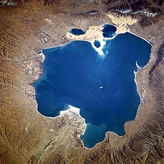
Deutsch: Qinghai-See, China - November 1994
English: Qinghai Lake, China - also, originally known as Koko Nor in Mongolian and Tso Ngonpo in Tibetan - November 1994
Español: Lago Qinghai, China - Noviembre 1994
中文:青海湖 |
|||||
| Datum | Fotografirano: 8. novembar 1994., 04:13:36 GMT | |||||
| Izvor |
https://eol.jsc.nasa.gov/sseop/EFS/photoinfo.pl?PHOTO=STS066-118-23 https://eol.jsc.nasa.gov/SearchPhotos/photo.pl?mission=STS066&roll=118&frame=23 |
|||||
| Autor | NASA | |||||
| Dopuštenje (Ponovna upotreba ove datoteke) |
|
|||||
| NASA information |
|

| Lokacija kamere | | Ova i druge slike na njihovim lokacijama na: OpenStreetMap |
|---|
This image or video was catalogued by one of the centers of the United States National Aeronautics and Space Administration (NASA) under Photo ID: STS066-118-23. This tag does not indicate the copyright status of the attached work. A normal copyright tag is still required. See Commons:Licensing. Other languages:
|
Historija datoteke
Kliknite na datum/vrijeme da biste vidjeli tadašnju verziju datoteke.
| Datum/vrijeme | Minijatura | Dimenzije | Korisnik | Komentar | |
|---|---|---|---|---|---|
| aktualna | 17:02, 10 oktobar 2005 | | 640 × 640 (138 kB) | Immanuel Giel | Qinghai Lake, China - November 1994 '''Source''': from the English Wikipedia<br> image description [http://eol.jsc.nasa.gov/sseop/EFS/photoinfo.pl?PHOTO=STS066-118-23 here] en:Qinghai Lake {{PD-USGov-NASA}} |
Upotreba datoteke
Sljedeća stranica koristi ovu datoteku:
Globalna upotreba datoteke
Ovu datoteku upotrebljavaju i sljedeći projekti:
- Upotreba na projektu ace.wikipedia.org
- Upotreba na projektu ar.wikipedia.org
- Upotreba na projektu ast.wikipedia.org
- Upotreba na projektu az.wikipedia.org
- Upotreba na projektu ba.wikipedia.org
- Upotreba na projektu be.wikipedia.org
- Upotreba na projektu bg.wikipedia.org
- Upotreba na projektu bn.wikipedia.org
- Upotreba na projektu bo.wikipedia.org
- Upotreba na projektu br.wikipedia.org
- Upotreba na projektu ca.wikipedia.org
- Upotreba na projektu cdo.wikipedia.org
- Upotreba na projektu ceb.wikipedia.org
- Upotreba na projektu cs.wikipedia.org
- Upotreba na projektu cv.wikipedia.org
- Upotreba na projektu da.wikipedia.org
- Upotreba na projektu de.wikipedia.org
- Upotreba na projektu el.wikipedia.org
- Upotreba na projektu en.wikipedia.org
- Upotreba na projektu en.wikivoyage.org
- Upotreba na projektu eo.wikipedia.org