Datoteka:Madjarska okupacija Backe i Baranje, 1941-1944.png

Veličina ovog prikaza: 615 × 600 piksela. Druge rezolucije: 246 × 240 piksela | 492 × 480 piksela | 886 × 864 piksela.
Izvorna datoteka (886 × 864 piksela, veličina datoteke/fajla: 67 kB, MIME tip: image/png)
Opis izmjene
| Opis |
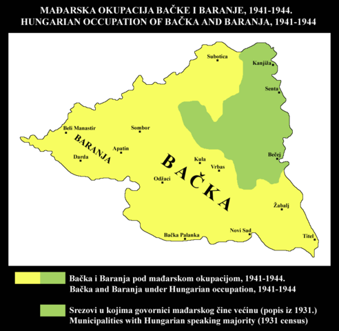
Srpski: Mađarska okupacija Bačke i Baranje, 1941-1944. Područje okupacije je upoređeno sa područjem srezova u kojima su govornici mađarskog bili u većini prema popisu iz 1931. Stanovništvo kojem maternji jezik nije bio mađarski činilo je većinu u najvećem delu ove teritorije koju je okupirala Mađarska. Korišćeni su podaci sa popisa iz 1931. iz ovog izvora: http://pod2.stat.gov.rs/ObjavljenePublikacije/G1931/Pdf/G19314001.pdf Jugoslovenske teritorije koje je u Drugom svetskom ratu okupirala Mađarska mogu se videti ovde: http://www.srpska-mreza.com/MAPS/Yugoslavia/YU-Nazi-division.jpg English: Hungarian occupation of Bačka and Baranja, 1941-1944. Area of occupation is compared with area of municipalities where speakers of Hungarian were in majority according to 1931 census. Population whose native language was not Hungarian formed the majority of inhabitants in most parts of this territory that was occupied by Hungary. I used 1931 census data from this source: http://pod2.stat.gov.rs/ObjavljenePublikacije/G1931/Pdf/G19314001.pdf Yugoslav territories occupied by Hungary in WW2 could be seen here: http://www.srpska-mreza.com/MAPS/Yugoslavia/YU-Nazi-division.jpg |
| Datum | |
| Izvor | Vlastito djelo |
| Autor | PPetrovic |
| Ostale verzije |
 |
Licenciranje
| Ja, vlasnik autorskog prava ovog djela, objavljujem ovaj rad u javno vlasništvo. Ovo se primjenjuje u cijelom svijetu. U nekim državama ovo zakonski nije moguće; u tom slučaju: Ja dopuštam svima pravo korištenja ovog rada u bilo koju svrhu, bez ikakvih uslova, osim ako su takvi uslovi zakonski neophodni. |
Historija datoteke
Kliknite na datum/vrijeme da biste vidjeli tadašnju verziju datoteke.
| Datum/vrijeme | Minijatura | Dimenzije | Korisnik | Komentar | |
|---|---|---|---|---|---|
| aktualna | 13:15, 22 maj 2014 | | 886 × 864 (67 kB) | PPetrovic | nova verzija |
| 20:32, 28 novembar 2012 |  | 886 × 864 (72 kB) | PANONIAN | revrted - this map is used in sr wikipedia. please upload your map version for en wikipedia under another filename | |
| 13:59, 28 novembar 2012 |  | 795 × 583 (30 kB) | DIREKTOR | De-greenified the yellow. | |
| 13:44, 28 novembar 2012 |  | 795 × 583 (28 kB) | DIREKTOR | Removed caption | |
| 23:36, 27 januar 2011 |  | 886 × 864 (72 kB) | PPetrovic | {{Information |Description=Hungarian occupation of Bačka and Baranja, 1941-1944. Area of occupation is compared with area of municipalities where speakers of Hungarian were in majority according to 1931 census. Population whose native language was not Hu |
Upotreba datoteke
Sljedećih 2 stranica koriste ovu datoteku:
Globalna upotreba datoteke
Ovu datoteku upotrebljavaju i sljedeći projekti:
- Upotreba na projektu sr.wikipedia.org