Datoteka:GoughMap ca 1360.jpg

Veličina ovog prikaza: 800 × 423 piksela. Druge rezolucije: 320 × 169 piksela | 640 × 339 piksela | 1.096 × 580 piksela.
Izvorna datoteka (1.096 × 580 piksela, veličina datoteke/fajla: 168 kB, MIME tip: image/jpeg)
Opis izmjene
| Opis |
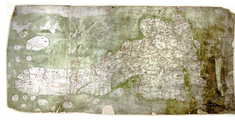
English: The Gough Map or Bodleian Map is a road map of Great Britain, dating from around 1360. The Gough Map is the oldest extant map of the roads of medieval Britain. It is about 115 x 56cm large and was made around 1360. It is named after Richard Gough, who donated the map to the Bodleian Library in 1809. East is on the top. |
| Datum | 1370-ih |
| Izvor | anonymous, Scan by the Bodleian Library |
| Autor | Nepoznat |
| Dopuštenje (Ponovna upotreba ove datoteke) |
PD-old |
| Ostale verzije | Higher resolution scan at File:Gough_Kaart_(hoge_resolutie).jpg |
.jpg)
| Ova datoteka potječe s Bodleianove knjižnice Sveučilišta u Oxfordu. This tag does not indicate the copyright status of the attached work. A normal copyright tag is still required. See Commons:Licensing. |
Links
- The Gough Map Bodleian Library information page
- Britain's first road map Oxford University Magazine 18,2 (2006)
- Interactive Map, joint effort of Queen's University Belfast and Bodleian Library
Licenciranje
|
This is a faithful photographic reproduction of a two-dimensional, public domain work of art. The work of art itself is in the public domain for the following reason:
The official position taken by the Wikimedia Foundation is that "faithful reproductions of two-dimensional public domain works of art are public domain".
This photographic reproduction is therefore also considered to be in the public domain in the United States. In other jurisdictions, re-use of this content may be restricted; see Reuse of PD-Art photographs for details. | ||||
Historija datoteke
Kliknite na datum/vrijeme da biste vidjeli tadašnju verziju datoteke.
| Datum/vrijeme | Minijatura | Dimenzije | Korisnik | Komentar | |
|---|---|---|---|---|---|
| aktualna | 14:03, 7 maj 2007 | | 1.096 × 580 (168 kB) | Mauss | {{Information |Description=The Gough Map or Bodleian Map is a road map of Great Britain, dating from around 1360. |Source= |Date= |Author= |Permission=PD-old |other_versions= }} |
Upotreba datoteke
Sljedeća stranica koristi ovu datoteku:
Globalna upotreba datoteke
Ovu datoteku upotrebljavaju i sljedeći projekti:
- Upotreba na projektu en.wikipedia.org
- Upotreba na projektu hr.wikipedia.org