Datoteka:Europe in 1923.jpg

Izvorna datoteka (7.097 × 5.456 piksela, veličina datoteke/fajla: 6,97 MB, MIME tip: image/jpeg)
Opis izmjene
| Opis |
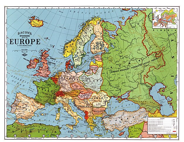
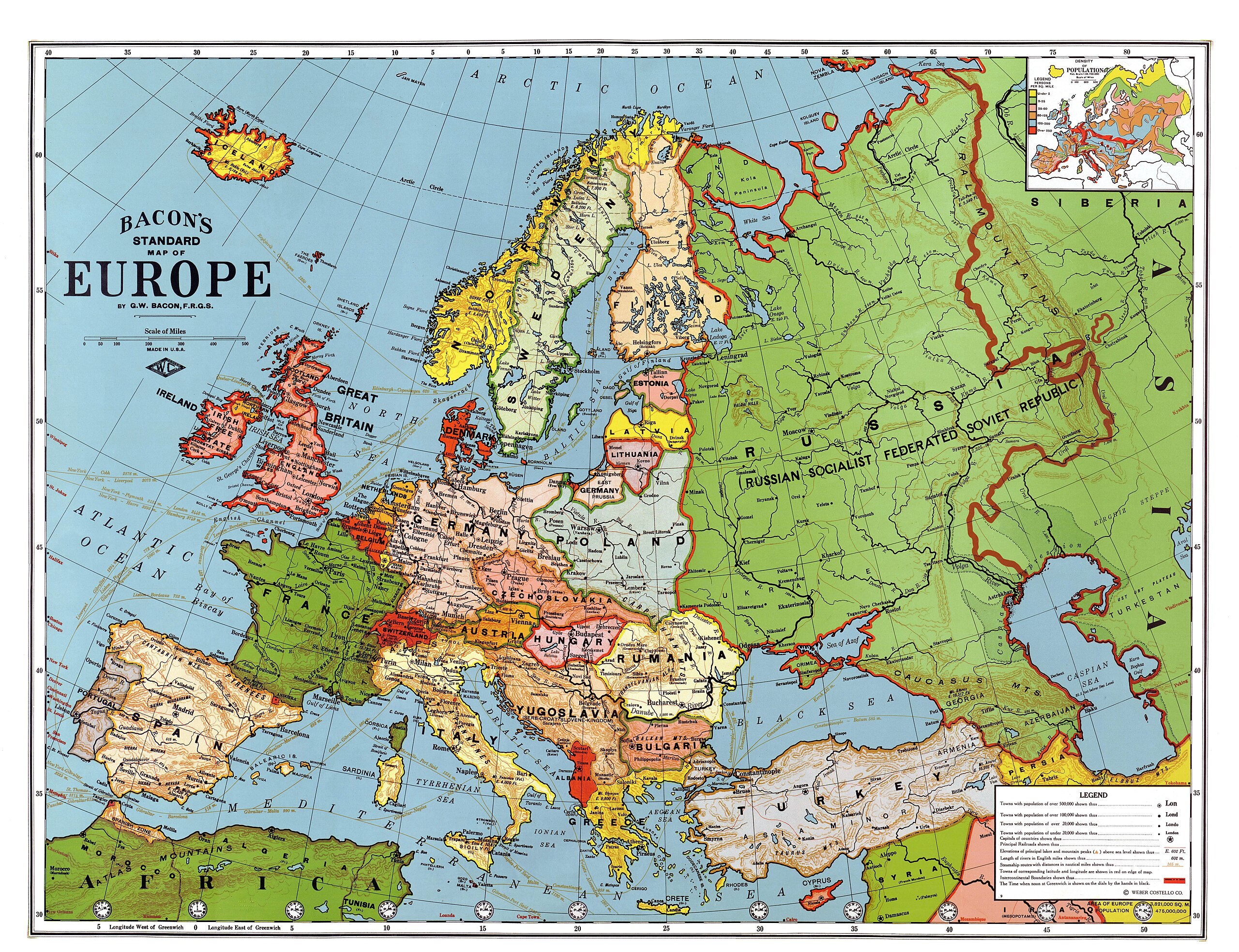
English: Bacon's standard map of Europe, 1923. Relief shown by hachures and spot heights. Shows steamship routes and time zones. Published by Weber Costello Co., 84 x 111 cm. Scale 1:5,500,000 (W 52°--E 80°/N 60°--N 30°).
Français : Carte "standard" de l'Europe au 1/5 500 000, par Bacon, 1923. Les reliefs sont donnés par des hachures et des indications de certaines altitudes. Les principales routes maritimes sont indiquées, ainsi que les fuseaŭx horaires. Publié par la compagnie Weber Costello, 84 x 111 cm.
Italiano: Carta geografica generale dell'Europa in lingua inglese (84 x 111 cm, scala 1:5 500 000), realizzata da G. W. Bacon e pubblicata da Weber Costello Co. nel 1923
Polski: Mapa Europy w skali 1:5500000 wydawnictwa Weber Costello Co. Uwzględnia granice z 1923 r. oraz m.in. szlaki morskie i strefy czasowe.
Türkçe: 1923 yılındaki ülke sınırlarını gösteren Avrupa haritası. Yükseltiler tarama çizgiler ve belli noktaların yükseklikleri ile belli edilmiştir. Saat dilimleri ve gemi yolları da gösterilmiştir. |
||
| Datum | nakon 1924 | ||
| Izvor |
|
||
| Kreator |
Bacon, George Washington (1830-1921) |
||
| Georeferencing | If inappropriate please set warp_status = skip to hide. | ||
| Ostale verzije |


| Ovo je retuširana slika, što znači da je digitalno izmjenjena u odnosu na svoju izvornu inačicu. Izmjene: Contrast enhanced, colors corrected, halves united. Izmjene je napravio: Alex:D. Izvornik se može vidjeti ovdje.
|
|

Ova je slika izabrana za sliku dana na Zajedničkom poslužitelju 27. svibnja 2010. Niže je njen naslov. English: George Washington Bacon's standard map of Europe, 1923. Relief shown by hachures and spot heights. Shows steamship routes and time zones. Published by Weber Costello Co., 84 × 111 cm. Scale 1:5,500,000 (W 52°--E 80°/N 60°--N 30°). Drugi jezici:
Čeština: Standardní mapa Evropy od George Washingtona Bacona z roku 1923; reliéf je značen šrafurou a kótami, vyznačeny jsou tratě parníků a časová pásma; měřítko 1 : 5 500 000, 84 × 111 cm Dansk: George Washington Bacons standardkort over Europa fra 1923. Topografien er vist med skraveringer, og punkter viser bjergtoppe. Kortet viser også skibsruter og tidszoner. Udgivet af Weber Costello Co, 88 × 111 cm. Målestok 1:5.500.000 (52°V - 80°Ø / 60°N - 30°N). Deutsch: George Washington Bacons Standardkarte von Europa von 1923. Die Topografie wird durch Schraffuren und Punkthöhen dargestellt. Ebenso sind Dampferrouten und Zeitzonen dargestellt. Veröffentlicht durch Weber Costello Co., 84 × 111 cm. Maßstab 1:5,500,000 (W 52°--E 80°/N 60°--N 30°). English: George Washington Bacon's standard map of Europe, 1923. Relief shown by hachures and spot heights. Shows steamship routes and time zones. Published by Weber Costello Co., 84 × 111 cm. Scale 1:5,500,000 (W 52°--E 80°/N 60°--N 30°). Español: Mapa estándar de Europa de George Washington Bacon, 1923. El relieve se muestra con líneas de sombra y puntos de altura. Incluye rutas de barcos a vapor y zonas horarias. Publicado por Weber Costello Co., 84×111 cm. Escala 1:5.500.000 (52° O–80° E/60° N–30° N). Français : Carte "standard" de l'Europe au 1/5 500 000, par Bacon, 1923. Les reliefs sont donnés par des hachures et des indications de certaines altitudes. Les principales routes maritimes sont indiquées, ainsi que les fuseaux horaires. Publié par la compagnie Weber Costello, 84 x 111 cm. Italiano: Carta geografica generale dell'Europa in lingua inglese (84 x 111 cm, scala 1:5 500 000), realizzata da G. W. Bacon e pubblicata da Weber Costello Co. nel 1923 Magyar: Európa-térkép 1923-ból, időzónákkal és hajóutakkal Nederlands: Standaardkaart van Europa uit 1923 van de Britse uitgever George Washington Bacon (1830-1922). De topografie wordt weergegeven door arceringen en hoogtepunten. Ook zijn stoombootroutes en tijdzones afgebeeld. Uitgegeven door Weber Costello Co. Afmeting: 84 × 111 cm. Schaal 1:5.500.000 (W 52° - E 80°/N 60° - N 30°). Português: Mapa da Europa publicado em 1923. Беларуская (тарашкевіца): Агульная мапа Эўропы Джорджа Вашынгтона Бэкана 1923 году. Выдадзена Weber Costello Co., 84 × 111 см. Маштаб 1:5 500 000 (З 52°—У 80°/П 60°—П 30°). Македонски: Бејконова стандардна карта на Европа на (1923). Релјефот е изразен со сенчање и коти. Прикажани се парабродски маршрути и часовни зони. Издавач: Weber Costello Co., 84 × 111 cm. Размер: 1:5.500.000 (З 52°--И 80°/С 60°--С 30°). Українська: Карта Європи 1923 року англійського видавця книг і мап Джорджа Вашінгтона Бейкена. Зображено рельєф, пароплавні маршрути, часові пояси. Надруковано Weber Costello Co., 84 × 111 см. Масштаб 1:5 500 000 (З 52°— С 80°/П 60° — П 30°). বাংলা : ১৯২৩ সালে জর্জ ওয়াশিংটন বেকন কর্তৃক অঙ্কিত ইউরোপের মানচিত্র। কোনো স্থানের উচ্চতা প্রদর্শিত হয়েছে, সেই সাথে বাষ্পীয় ইঞ্জিন চালিত জাহাজের চলাচলের পথ ও সময়স্থানও সূচিত হয়েছে। এটি প্রকাশ করেছিলো ওয়েবার ক্যাসটেল্লো কোম্পানি। প্রকাশের সময় এর আকৃতি ছিলো ৮৪ × ১১১ সেন্টিমিটার। স্কেল ১:৫,৫০০,০০০ (প্রদর্শিত স্থান: ৫২° পশ্চিম - ৮০° পূর্ব ও ৬০° উত্তর থেকে ৩০° উত্তর)। 한국어: 1923년의 유럽 지도. 日本語: 「ベーコンの標準ヨーロッパ地図」縮尺 1 : 5,500,000。1923年アメリカ製。 中文: 1923年版本的欧洲地图,比例尺为1:5,500,000,尺寸为84 x 111 cm 中文(繁體): 1923年版本的歐洲地圖,比例尺為1:5,500,000,尺寸為84 x 111 cm。 |
Licenciranje
|
Ovo je djelo u javnom vlasništvu u zemlji podrijetla i u drugim zemljama s rokom trajanja autorskih prava za života autora plus 70 godina ili manje.
| |
| Ova datoteka je identificirana kao slobodna od poznatih ograničenja po zakonu o autorskim pravima, uključujući sva povezana i srodna prava. | |
This media file is in the public domain in the United States. This applies to U.S. works where the copyright has expired, often because its first publication occurred prior to January 1, 1929, and if not then due to lack of notice or renewal. See this page for further explanation.
|
 | |
 |
This image might not be in the public domain outside of the United States; this especially applies in the countries and areas that do not apply the rule of the shorter term for US works, such as Canada, Mainland China (not Hong Kong or Macao), Germany, Mexico, and Switzerland. The creator and year of publication are essential information and must be provided. See Wikipedia:Public domain and Wikipedia:Copyrights for more details.
|
_en.png)
.png)
.jpg)
Historija datoteke
Kliknite na datum/vrijeme da biste vidjeli tadašnju verziju datoteke.
| Datum/vrijeme | Minijatura | Dimenzije | Korisnik | Komentar | |
|---|---|---|---|---|---|
| aktualna | 16:15, 25 januar 2013 | | 7.097 × 5.456 (6,97 MB) | Slick-o-bot | Bot: convert to a non-interlaced jpeg (see bug #17645) |
| 08:58, 1 maj 2009 |  | 7.097 × 5.456 (6,54 MB) | Alex:D | {{Information |Description= {{en|Bacon's standard map of Europe, 1923. Published by Weber Costello Co., 84 x 111 cm. Relief shown by hachures and spot heights. Shows steamship routes and time zones. Scale 1:5,500,000 (W 52°--E 80°/N 60°--N 30°).} |
Upotreba datoteke
Sljedeća stranica koristi ovu datoteku:
Globalna upotreba datoteke
Ovu datoteku upotrebljavaju i sljedeći projekti:
- Upotreba na projektu af.wikipedia.org
- Upotreba na projektu ar.wikipedia.org
- Upotreba na projektu ast.wikipedia.org
- Upotreba na projektu ba.wikipedia.org
- Upotreba na projektu bg.wikipedia.org
- Upotreba na projektu bn.wikipedia.org
- Upotreba na projektu bs.wikipedia.org
- Upotreba na projektu crh.wikipedia.org
- Upotreba na projektu cs.wikipedia.org
- Upotreba na projektu cv.wikipedia.org
- Upotreba na projektu cy.wikipedia.org
- Upotreba na projektu da.wikipedia.org
- Upotreba na projektu de.wikipedia.org
- Upotreba na projektu en.wikipedia.org
- Russian Civil War
- Treaty of Brest-Litovsk
- Interwar period
- User talk:Alex:D
- Wikipedia:Featured pictures/Diagrams, drawings, and maps/Maps
- Wikipedia:WikiProject Military history/Showcase
- Wikipedia:WikiProject Military history/Showcase/FP
- Wikipedia:Graphics Lab/Map workshop/Archive/Jan 2010
- User:Kazkaskazkasako/Books/History
- Revolutions of 1917–1923
- User:Dtale1984
- 1937 tour of Germany by the Duke and Duchess of Windsor
- Wikipedia:WikiProject Women in Red/Meetup/135
- User:Falcaorib
- User:RJMwikiboy/sandbox
- Wikipedia:Featured pictures thumbs/67
- User:Ssss2323/sandbox
- Wikipedia:Featured picture candidates/June-2020
- Wikipedia:Featured picture candidates/A map of interwar Europe, 1923
- Wikipedia:Wikipedia Signpost/2020-06-28/Featured content
- Wikipedia:Wikipedia Signpost/Single/2020-06-28
- Portal:History/Recognized content
- Wikipedia:Picture of the day/May 2022
- Template:POTD/2022-05-09
- Wikipedia:Main Page history/2022 May 9
- Wikipedia:Main Page history/2022 May 9b
- User talk:TheFreeWorld/Archive 1
- Upotreba na projektu en.wikibooks.org
- Upotreba na projektu eo.wikiquote.org
- Upotreba na projektu es.wikipedia.org
- Upotreba na projektu es.wikibooks.org
- Upotreba na projektu et.wikipedia.org