Datoteka:East-Hem 477ad.jpg
Izvorna datoteka (3.240 × 1.903 piksela, veličina datoteke/fajla: 760 kB, MIME tip: image/jpeg)

|
This historical map image could be re-created using vector graphics as an SVG file. This has several advantages; see Commons:Media for cleanup for more information. If an SVG form of this image is available, please upload it and afterwards replace this template with
{{vector version available|new image name}}.
It is recommended to name the SVG file “East-Hem 477ad.svg”—then the template Vector version available (or Vva) does not need the new image name parameter. |


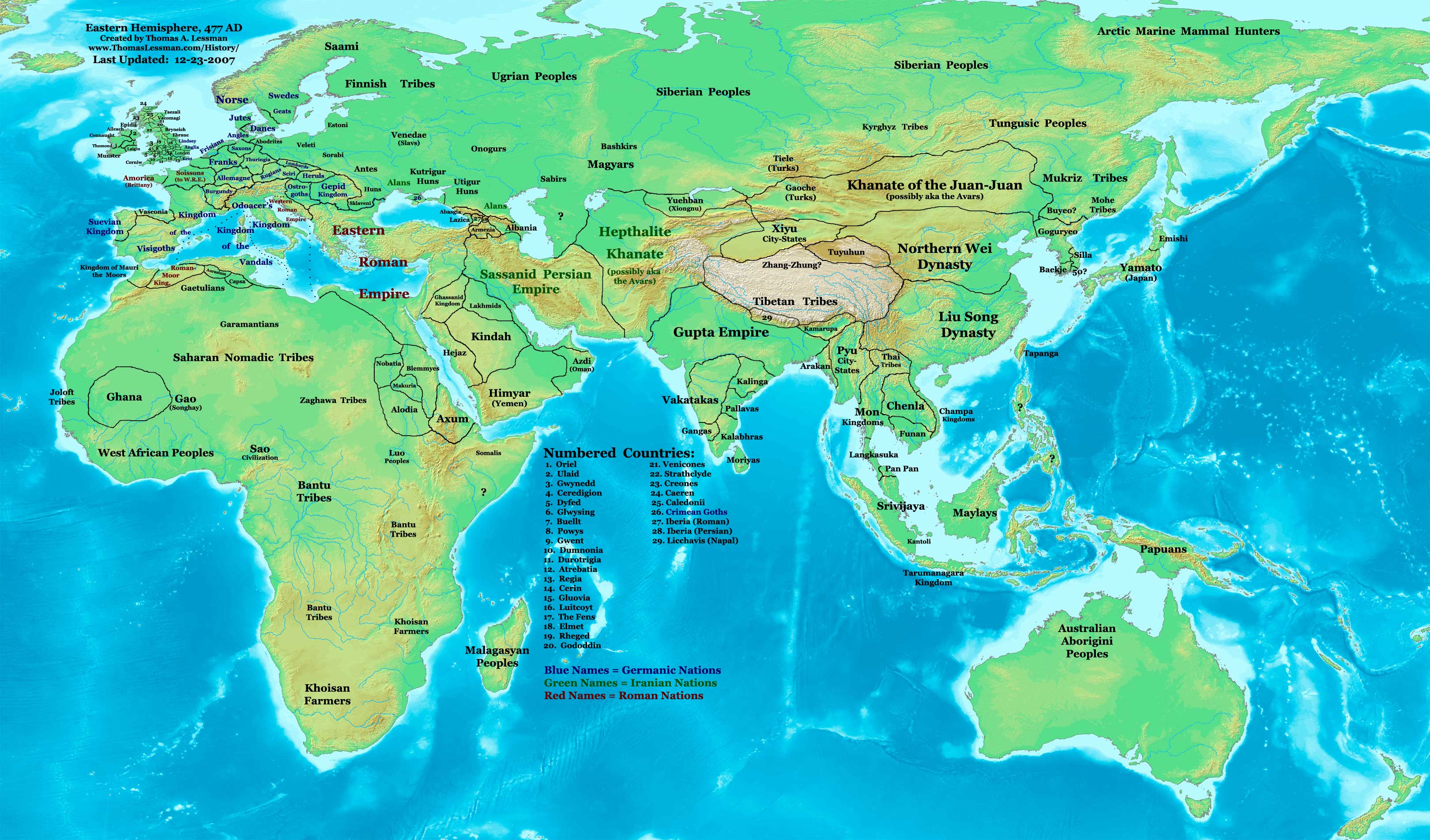
| Opis | Eastern Hemisphere in 477 AD. |
| Izvor | self-made (For reference information, see the Map Source References section below.) |
| Autor | Thomas Lessman (Contact!) |
| Dopuštenje (Ponovna upotreba ove datoteke) |
Ja, vlasnik autorskog prava ovog djela, ovdje ga objavljujem pod sljedećom licencom: Ova datoteka dostupna je pod licencom Creative Commons Attribution-Share Alike 3.0 Unported licencom.
|
| Ostale verzije | see East-Hem_477ad.jpg file history on Wikipedia. |
Izvorna evidencija postavljanja
- 2008-01-30 21:43 Talessman 3240×1903×8 (771773 bytes) Updated version, many corrections and improvements
- 2007-07-21 20:25 Talessman 1973×1159×8 (2352310 bytes) Author: Thomas A. Lessman. Source URL: http://www.ThomasLessman.com/History/images/East-Hem_477ad.jpg. Image was created by me (Thomas Lessman) based on historical information located on Wikipedia, as well as information from maps located in Wikipedia and
Map Summary
Original Source URL: http://www.thomaslessman.com/History/images/East-Hem_476ad.jpg.
This map of the Eastern Hemisphere in 477 AD was created by Thomas Lessman, based on information from the sources listed below. This map is free for educational use (see Permission info above). When using this map, please mention that it is available for free at www.WorldHistoryMaps.info.
Map Source References
- Remember, sources often conflict with each other. This map is only as accurate as the information that is available to me. To report any errors or to help further this work, please click here, or email Thomas Lessman at talessman@yis.us
References for information contained in this map:
1. Borders of Europe are mostly derived from the Euratlas.com map of Europe in 500 AD.
2. Borders of Britain are derived from the "EarlyBritishKingdoms.com", map of map Britain in 475 AD.
3. Borders of Asian countries derive from various Wikipedia articles and Google history map searches.
4. Some information is derived from Wikimedia's map of The world in 500 CE, created by User:Javierfv1212.
5. Much of the information in this map was cross-checked with Bruce Gordon's Regnal Chronologies.
Other Maps in this Series
| Maps of the eastern hemisphere showing history
Bold dates are available on Wikimedia or Wikipedia. | ||
| Primeval | ||
| Ancient
|
·| 600 BC | 550 BC | 527 BC | 500 BC |
400 BC | ·| 1 AD | 50 AD | 100 AD | 200 AD | 300 AD | | |
| Medieval |
·| 500 AD | 565 AD | 600 AD | 700 AD | | |
| Modern |
·| 1500 AD | · * For historical maps of the whole world, | |
Historija datoteke
Kliknite na datum/vrijeme da biste vidjeli tadašnju verziju datoteke.
| Datum/vrijeme | Minijatura | Dimenzije | Korisnik | Komentar | |
|---|---|---|---|---|---|
| aktualna | 19:41, 9 maj 2008 | | 3.240 × 1.903 (760 kB) | Talessman | {{Information |Description=Eastern Hemisphere in 477 AD. |Source=self-made |Author=User:Talessman |Permission={{self|cc-by-sa-3.0}} }} |
Upotreba datoteke
Sljedeća stranica koristi ovu datoteku:
Globalna upotreba datoteke
Ovu datoteku upotrebljavaju i sljedeći projekti:
- Upotreba na projektu en.wikipedia.org
- Upotreba na projektu rue.wikipedia.org
- Upotreba na projektu sv.wikipedia.org