Datoteka:Balkan battlegrounds LOC 2010588135-12.jpg

Veličina ovog prikaza: 462 × 599 piksela. Druge rezolucije: 185 × 240 piksela | 370 × 480 piksela | 592 × 768 piksela | 789 × 1.024 piksela | 1.579 × 2.048 piksela | 3.392 × 4.400 piksela.
Izvorna datoteka (3.392 × 4.400 piksela, veličina datoteke/fajla: 1,57 MB, MIME tip: image/jpeg)
Opis izmjene
| Opis |
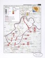
English: Regional maps showing troop positions, troop movements, and battle-front lines during the Yugoslav conflict of 1991-1995. Relief shown by contours, shading, and spot heights. Title from map slipcase. Map scales range from ca. 1:500,000 (Slovenia map) to ca. 1:50,000. Includes 2 paperbound history texts titled: Balkan battlegrounds--a military history of the Yugoslav conflict, 1990-1995. xxx, 501 p. : col. ill., index ; 28 cm. (vol. 1). -- ix, 580 p. : index ; 28 cm. (vol. 2). Includes coverage map (inset) and geographic coordinates. Some maps also include note. Bibliographic notes in accompanying texts. Available also through the Library of Congress Web site as a raster image. The names of the months have been abbreviated in the contents note that gives the individual map titles. Accompanying texts are filed on set shelf. |
||
| Title | Balkan battlegrounds | ||
| Shelf ID | G6841.S73 svar .U4 | ||
| Parent | https://www.loc.gov/resource/g6841sm.gct00210/ | ||
| Sheet title | Bosnia: Bosanski Brod, July-October 1992 | ||
| Datum | d1995 | ||
| Izvor | https://www.loc.gov/item/2010588135/ | ||
| Autor | United States. Central Intelligence Agency. Office Of Russian And European Analysis | ||
| Dopuštenje (Ponovna upotreba ove datoteke) |
|
||
| Ostale verzije |
|
||
| Location | Slovenia · Former Yugoslav Republics · Croatia · Bosnia And Herzegovina | ||
| Part of | Military Battles And Campaigns · American Memory · Catalog · Geography And Map Division | ||
| Subject | Former Yugoslav Republics · Yugoslav War · Slovenia · 20Th Century · Campaigns · Maps · Croatia · Bosnia And Herzegovina · History, Military · Bosnia And Hercegovina · History |

Licenciranje
| This image is a work of a Central Intelligence Agency employee, taken or made as part of that person's official duties. As a Work of the United States Government, this image or media is in the public domain in the United States.
|

|
Historija datoteke
Kliknite na datum/vrijeme da biste vidjeli tadašnju verziju datoteke.
| Datum/vrijeme | Minijatura | Dimenzije | Korisnik | Komentar | |
|---|---|---|---|---|---|
| aktualna | 05:31, 1 novembar 2018 | | 3.392 × 4.400 (1,57 MB) | Fæ | LOC Maps multisheet https://www.loc.gov/item/2010588135/ sheet 12 of 62 #25824 |
Upotreba datoteke
Sljedeća stranica koristi ovu datoteku: