Datoteka:1853 Mitchell Map of Turkey in Europe and Greece ( Greece, Balkans, Macedonia ) - Geographicus - TurkeyEurope-mitchell-1850.jpg

Veličina ovog prikaza: 489 × 600 piksela. Druge rezolucije: 196 × 240 piksela | 391 × 480 piksela | 626 × 768 piksela | 834 × 1.024 piksela | 2.445 × 3.000 piksela.
Izvorna datoteka (2.445 × 3.000 piksela, veličina datoteke/fajla: 2,91 MB, MIME tip: image/jpeg)
_-_Geographicus_-_TurkeyEurope-mitchell-1850.jpg)
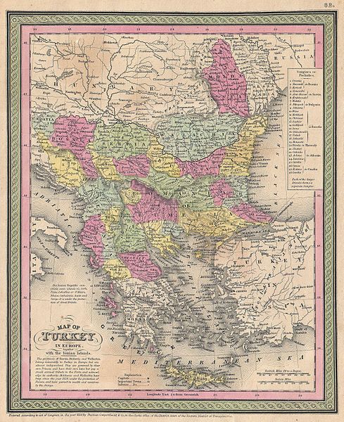
| Samuel Augustus Mitchell: Map of Turkey in Europe together with the Ionian Islands.
( |
||||||||||||||||||||
|---|---|---|---|---|---|---|---|---|---|---|---|---|---|---|---|---|---|---|---|---|
| Umetnik |
|
|||||||||||||||||||
| Naslov |
Map of Turkey in Europe together with the Ionian Islands. |
|||||||||||||||||||
| Opis |
English: An extremely attractive example of S. A. Mitchell Sr.’s 1853 map of Turkey in Europe. This map, made when the Ottoman Empire controlled much of the region, covers what is today Turkey, Greece, Macedonia Croatia, Bosnia, Serbia, Romania, Bulgaria, Macedonia and Albania. Ottoman provinces are color coded and numbered. Surrounded by the green border common to Mitchell maps from the 1850s. Prepared by S. A. Mitchell for issued as plate no. 62 in the 1853 edition of his New Universal Atlas . Dated and copyrighted, “Entered according to act of Congress, in the year 1850, by Thomas Cowperthwait & Co., in the Clerks office of the District court of the Eastern District of Pennsylvania. |
|||||||||||||||||||
| Datum | 1850 (dated) | |||||||||||||||||||
| Dimenzije | visina: 12,5 in (31,7 cm); širina: 10 in (25,4 cm) | |||||||||||||||||||
| Popisni broj |
Geographicus link: TurkeyEurope-mitchell-1850 |
|||||||||||||||||||
| Izvor/fotograf |
A New Universal Atlas Containing Maps of the various Empires, Kingdoms, States and Republics Of The World. (1853 issue)
|
|||||||||||||||||||
| Dopuštenje (Ponovna upotreba ove datoteke) |
|
|||||||||||||||||||
Historija datoteke
Kliknite na datum/vrijeme da biste vidjeli tadašnju verziju datoteke.
| Datum/vrijeme | Minijatura | Dimenzije | Korisnik | Komentar | |
|---|---|---|---|---|---|
| aktualna | 15:46, 22 mart 2011 | | 2.445 × 3.000 (2,91 MB) | BotMultichillT | {{subst:User:Multichill/Geographicus |link=http://www.geographicus.com/P/AntiqueMap/TurkeyEurope-mitchell-1850 |product_name=1853 Mitchell Map of Turkey in Europe and Greece ( Greece, Balkans, Macedonia ) |map_title=Map of Turkey in Europe together with t |
Upotreba datoteke
Sljedeća stranica koristi ovu datoteku:
Globalna upotreba datoteke
Ovu datoteku upotrebljavaju i sljedeći projekti:
_-_Geographicus_-_TurkeyEurope-mitchell-1850.jpg)