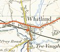
Datoteka:Whitlandmap1952.jpg

Izvorna datoteka(740 × 642 piksela, veličina datoteke/fajla: 278 kB, MIME tip: image/jpeg)

Ova datoteka je s projekta Vikimedijina ostava i može se upotrebljavati i na drugim projektima. Ispod su prikazane informacije s njene opisne stranice.

This work is an Ordnance Survey map over 50 years old, which is covered by Crown Copyright which in this case expires 50 years after publication. Ordnance Survey does however ask that they be credited and that the date of publication be given. Any ancillary rights gained through the creation of the electronic version are granted as freely usable under any circumstances.
Public domain
This work created by the United Kingdom Government is in the public domain.

This is because it is one of the following:

  1. It is a photograph taken prior to 1 June 1957; or
  2. It was published prior to 1974; or
  3. It is an artistic work other than a photograph or engraving (e.g. a painting) which was created prior to 1974.

HMSO has declared that the expiry of Crown Copyrights applies worldwide (ref: HMSO Email Reply)
More information.

See also Copyright and Crown copyright artistic works.

Deutsch  English  Español  français  italiano  Nederlands  polski  português  sicilianu  slovenščina  suomi  Türkçe  македонски  русский  українська  മലയാളം  한국어  日本語  简体中文  繁體中文  العربية  +/−

Opis map of Whitland at 1 inch to the mile scale scanned at 600 DPI
Datum
Izvor OS map carmarthen and tenbysheet 152 1952
Autor OS
Ostale verzije Image:Whitlandrailway lines map1952.jpg

Opisi

Dodajte objašnjenje u jednom redu što predstavlja ova datoteka

Predmeti pokazani na ovoj datoteci

prikazuje

Historija datoteke

Kliknite na datum/vrijeme da biste vidjeli tadašnju verziju datoteke.

Datum/vrijemeMinijaturaDimenzijeKorisnikKomentar
aktualna17:21, 26 februar 2007Minijatura verzije (17:21, 26 februar 2007)740 × 642 (278 kB)Geni{{oldOS}} {{Information |Description=map of Whitland at 1 inch to the mile scale scanned at 600 DPI |Source=OS map carmarthen and tenbysheet 152 1952 |Date=1952 |Author=OS |Permission=none needed |other_versions= }} Category:Maps of Wales [[Category:

Sljedeća stranica koristi ovu datoteku:

Globalna upotreba datoteke

Ovu datoteku upotrebljavaju i sljedeći projekti:

  • Upotreba na projektu en.wikipedia.org

Metapodaci