Datoteka:Larose Louisiana aerial view.jpg

Veličina ovog prikaza: 800 × 533 piksela. Druge rezolucije: 320 × 213 piksela | 640 × 427 piksela | 1.024 × 683 piksela | 1.500 × 1.000 piksela.
Izvorna datoteka (1.500 × 1.000 piksela, veličina datoteke/fajla: 278 kB, MIME tip: image/jpeg)
| Opis |
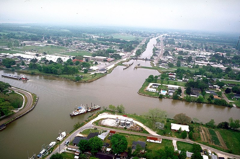
English: Aerial view of the intersection of Bayou Lafourche and the Gulf Intracoastal Waterway at Larose, Louisiana, USA. The waterway runs left–right across the photograph and the bayou runs off into the distance at the top. The U.S. Army Corps of Engineers has installed a floodgate on the bayou, visible at center. |
|||
| Datum | ||||
| Izvor |
U.S. Army Corps of Engineers Digital Visual Library Image page Image description page Digital Visual Library home page |
|||
| Autor | Arthur Belala, U.S. Army Corps of Engineers | |||
| Dopuštenje (Ponovna upotreba ove datoteke) |
|
|||
| Lokacija | Larose, Louisiana, USA |
| Lokacija kamere | | Ova i druge slike na njihovim lokacijama na: OpenStreetMap |
|---|
Historija datoteke
Kliknite na datum/vrijeme da biste vidjeli tadašnju verziju datoteke.
| Datum/vrijeme | Minijatura | Dimenzije | Korisnik | Komentar | |
|---|---|---|---|---|---|
| aktualna | 18:28, 1 april 2007 | | 1.500 × 1.000 (278 kB) | DanMS | {{Information | Description = {{en|Aerial view of the intersection of Bayou Lafourche and the Gulf Intracoastal Waterway at Larose, Louisiana, USA. The bayou runs left–right across the photograph and the waterway runs off into the distance at the top |
Upotreba datoteke
Sljedeća stranica koristi ovu datoteku:
Globalna upotreba datoteke
Ovu datoteku upotrebljavaju i sljedeći projekti:
- Upotreba na projektu ar.wikipedia.org
- Upotreba na projektu azb.wikipedia.org
- Upotreba na projektu ca.wikipedia.org
- Upotreba na projektu ceb.wikipedia.org
- Upotreba na projektu ce.wikipedia.org
- Upotreba na projektu de.wikipedia.org
- Upotreba na projektu en.wikipedia.org
- Upotreba na projektu es.wikipedia.org
- Upotreba na projektu fa.wikipedia.org
- Upotreba na projektu fr.wikipedia.org
- Upotreba na projektu it.wikipedia.org
- Upotreba na projektu ja.wikipedia.org
- Upotreba na projektu lld.wikipedia.org
- Upotreba na projektu pl.wikipedia.org
- Upotreba na projektu pt.wikipedia.org
- Upotreba na projektu sr.wikipedia.org
- Upotreba na projektu tt.wikipedia.org
- Upotreba na projektu uk.wikipedia.org
- Upotreba na projektu www.wikidata.org
- Upotreba na projektu zh-min-nan.wikipedia.org
- Upotreba na projektu zh.wikipedia.org