Datoteka:European Middle Neolithic.gif
Veličina ovog prikaza: 800 × 397 piksela. Druge rezolucije: 320 × 159 piksela | 640 × 317 piksela | 1.307 × 648 piksela.
Izvorna datoteka (1.307 × 648 piksela, veličina datoteke/fajla: 101 kB, MIME tip: image/gif)
Opis izmjene

|
Dostupna je vektorska inačica (SVG) ove slike. Trebala bi se koristiti umjesto ove rasterske slike ako je kvalitetnija.
File:European Middle Neolithic.gif → File:European-middle-neolithic-en.svg
Za više informacija o vektorskoj grafici, pročitajte o prelasku Zajedničkog poslužitelja na SVG. Također pročitajte informacije o podršci MediaWiki softvera slikama u SVG formatu. |
 |
.
| Opis |
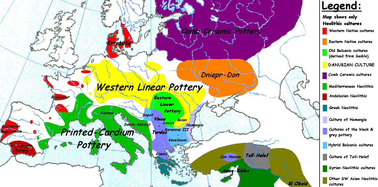
English: Map of the second half European Middle Neolithic at the apogee of Danubian and Mediterranean expansion. (The modification of the original map - Combed pottery, earlier notated as Pitted Ware, see history without respecting the color code of the legend is something that I am not fully satisfied with). |
| Datum | 5. april 2005. (izvorni datum postavljanja) |
| Izvor | Transferred from en.wikipedia to Commons. |
| Autor |
Sugaar na Wikipedia na Engleski Later versions were uploaded by Clarifer at en.wikipedia. |
| Ostale verzije |
[]
|


_en.png)
.png)
.jpg)
Licenciranje
| Ovaj rad je objavljen u javno vlasništvo od strane autora Sugaar na Wikipedia na Engleski. Ovo se primjenjuje širom svijeta. U nekim državama ovo zakonski nije moguće; u tom slučaju: Sugaar dopušta svima pravo korištenja ovog rada u bilo koju svrhu, bez ikakvih uslova, osim ako su takvi uslovi zakonski neophodni. |
Izvorna evidencija postavljanja
The original description page was here. All following user names refer to en.wikipedia.
- 2005-08-28 13:11 Clarifer 1320×663×8 (106148 bytes) Added the approximate area of the Comb Ceramic culture. Source: National Board of Antiquities, Finland. www.nba.fi
- 2005-04-05 20:12 Sugaar 1320×663×8 (103228 bytes) Map of the second half European Middle Neolithic at the apogee of Danubian and Mediterranean expansion (c. 4500-4000 BCE). Made by [[Sugaar]]. Free use authorized by the author.
Historija datoteke
Kliknite na datum/vrijeme da biste vidjeli tadašnju verziju datoteke.
| Datum/vrijeme | Minijatura | Dimenzije | Korisnik | Komentar | |
|---|---|---|---|---|---|
| aktualna | 08:43, 18 april 2014 | | 1.307 × 648 (101 kB) | Spiridon Ion Cepleanu | Neolithic shorelines and banks, little details |
| 02:39, 22 mart 2010 |  | 1.307 × 648 (101 kB) | Ras67 | cropped | |
| 02:50, 14 februar 2007 |  | 1.320 × 663 (104 kB) | 32X | Auf eine alte Version zurückgesetzt | |
| 02:49, 14 februar 2007 |  | 1.320 × 663 (101 kB) | 32X | Original version by Sugaar. | |
| 13:14, 31 decembar 2005 |  | 1.320 × 663 (104 kB) | Glenn | Originally uploaded to en-wiki: Quote: "Map of the second half European Middle Neolithic at the apogee of Danubian and Mediterranean expansion (c. 4500-4000 BCE)." Upload text: "20:12, 5 April 2005 . . Sugaar . . 1320x663 (103228 bytes) (Map of the secon |
Upotreba datoteke
Sljedećih 2 stranica koriste ovu datoteku:
Globalna upotreba datoteke
Ovu datoteku upotrebljavaju i sljedeći projekti:
- Upotreba na projektu az.wikipedia.org
- Upotreba na projektu be.wikipedia.org
- Upotreba na projektu bg.wikipedia.org
- Upotreba na projektu bs.wikipedia.org
- Upotreba na projektu ca.wikipedia.org
- Upotreba na projektu cs.wikipedia.org
- Upotreba na projektu da.wikipedia.org
- Upotreba na projektu da.wikibooks.org
- Upotreba na projektu de.wikipedia.org
- Upotreba na projektu en.wikipedia.org
- Upotreba na projektu et.wikipedia.org
- Upotreba na projektu fi.wikipedia.org
- Upotreba na projektu fi.wikibooks.org
- Upotreba na projektu gl.wikipedia.org
- Upotreba na projektu he.wikipedia.org
- Upotreba na projektu hi.wikipedia.org
- Upotreba na projektu hr.wikipedia.org
- Upotreba na projektu hu.wikipedia.org
- Upotreba na projektu it.wikipedia.org