Datoteka:Biot-map.png

Veća rezolucija nije dostupna.
Biot-map.png (328 × 353 piksela, veličina datoteke/fajla: 5 kB, MIME tip: image/png)

|
This map image could be re-created using vector graphics as an SVG file. This has several advantages; see Commons:Media for cleanup for more information. If an SVG form of this image is available, please upload it and afterwards replace this template with
{{vector version available|new image name}}.
It is recommended to name the SVG file “Biot-map.svg”—then the template Vector version available (or Vva) does not need the new image name parameter. |
Transferred from en.wikipedia to Commons by Maksim.
The original description page was here. All following user names refer to en.wikipedia.
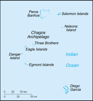
Map of the British Indian Ocean Territory from CIA World Factbook.
Ova je slika u javnom vlasništvu jer sadrži materijale iz World Factbooka u izdanju američke Središnje obavještajne agencije (CIA).
|
 |
| date/time | username | edit summary |
|---|---|---|
| 22:56, 12 November 2004 | en:User:BrokenSegue | ({{PD-USGov-CIA-WF}}) |
| 06:17, 4 June 2004 | en:User:Template namespace initialisation script | |
| 20:15, 23 May 2004 | en:User:Grendelkhan | (clear up PD message) |
| 20:14, 23 May 2004 | en:User:Grendelkhan | (Map of the British Indian Ocean Territory from [http://www.lib.utexas.edu/maps/cia03/british_indian_ocean_sm03.gif CIA World Factbook].<br><br>{{msg:PD}}) |
Izvorna evidencija postavljanja
Legend: (cur) = this is the current file, (del) = delete this old version, (rev) = revert to this old version.
Click on date to download the file or see the image uploaded on that date.
- (del) (cur) 22:14, 24 May 2005 . . en:User:Hoshie Hoshie ( en:User_talk:Hoshie Talk) . . 328x353 (4977 bytes) (updated map from 2005 CIA World Factbook, now with a lowercase file name.)
- (del) (rev) 20:14, 23 May 2004 . . en:User:Grendelkhan Grendelkhan ( en:User_talk:Grendelkhan Talk) . . 329x355 (4794 bytes) (Map of the British Indian Ocean Territory from CIA World Factbook.<br><br>{ { msg:PD } })
Historija datoteke
Kliknite na datum/vrijeme da biste vidjeli tadašnju verziju datoteke.
| Datum/vrijeme | Minijatura | Dimenzije | Korisnik | Komentar | |
|---|---|---|---|---|---|
| aktualna | 23:11, 12 maj 2006 | | 328 × 353 (5 kB) | Frankie Roberto~commonswiki | Map of the British Indian Ocean Territory from [http://www.lib.utexas.edu/maps/cia03/british_indian_ocean_sm03.gif CIA World Factbook]. {{PD-USGov-CIA-WF}} (copied from http://en.wikipedia.org/wiki/Image:Biot-map.png for use on Wikinews) |
| 13:13, 26 mart 2006 |  | 328 × 353 (5 kB) | Maksim | La bildo estas kopiita de wikipedia:en. La originala priskribo estas: Map of the British Indian Ocean Territory from [http://www.lib.utexas.edu/maps/cia03/british_indian_ocean_sm03.gif CIA World Factbook]. {{PD-USGov-CIA-WF}} {| border="1" ! date/time |
Upotreba datoteke
Sljedećih 2 stranica koriste ovu datoteku:
Globalna upotreba datoteke
Ovu datoteku upotrebljavaju i sljedeći projekti:
- Upotreba na projektu af.wikipedia.org
- Upotreba na projektu arz.wikipedia.org
- Upotreba na projektu ast.wikipedia.org
- Upotreba na projektu bs.wikipedia.org
- Upotreba na projektu ca.wikipedia.org
- Upotreba na projektu da.wikipedia.org
- Upotreba na projektu de.wikipedia.org
- Upotreba na projektu el.wikipedia.org
- Upotreba na projektu en.wikipedia.org
- Upotreba na projektu en.wikinews.org
- Upotreba na projektu eo.wikipedia.org
- Upotreba na projektu es.wikipedia.org
- Upotreba na projektu fa.wikipedia.org
- Upotreba na projektu fr.wikipedia.org
- Upotreba na projektu ga.wikipedia.org
- Upotreba na projektu gl.wikipedia.org
- Upotreba na projektu hr.wikipedia.org
- Upotreba na projektu hu.wikipedia.org
- Upotreba na projektu incubator.wikimedia.org
- Upotreba na projektu it.wikipedia.org
- Upotreba na projektu ja.wikipedia.org
- Upotreba na projektu ko.wikipedia.org
- Upotreba na projektu lij.wikipedia.org
- Upotreba na projektu lt.wikipedia.org
- Upotreba na projektu mzn.wikipedia.org
- Upotreba na projektu nl.wikipedia.org
- Upotreba na projektu pl.wikipedia.org
- Upotreba na projektu pt.wikipedia.org
- Upotreba na projektu ro.wikipedia.org
- Upotreba na projektu ru.wikipedia.org